Two very different mountains
Chittenden County has a mountain for every ability, and two of them stand out so completely that they define how Vermonters picture their own state. Camel’s Hump is the wild one: 4,083 feet of undeveloped summit, no road, no lift, no buildings, its distinctive double-humped profile stamped on the Vermont state quarter and the state’s conservation seal. Mount Philo is the gentle one: a 968-foot bump at the edge of the Champlain Valley with a paved road to the top, picnic tables, and one of the most photographed views in New England.
Between them they cover the whole spectrum. Camel’s Hump is a serious, strenuous day hike — five to seven miles round trip with 2,000 to 2,600 feet of climbing, alpine tundra at the top and weather that turns without warning. Mount Philo is a twenty-minute walk or a two-minute drive, suitable for a stroller, a toddler or a grandparent, and it delivers a panorama that rivals summits ten times its height.
This guide covers both properly: every trail option, timing, parking, what the views actually show you, the history and ecology that make each mountain unusual, safety and seasonal considerations, and the other summits nearby worth adding to a Vermont hiking trip.
Camel’s Hump: the mountain Vermont chose to leave alone
Camel’s Hump is the third-highest peak in Vermont, after Mount Mansfield and Killington, and by a wide margin the most beloved. The reason is what is not there. Mansfield has a toll road, a gondola and a ski area on its flanks; Killington is a resort. Camel’s Hump has nothing — no summit structures, no vehicle access, no commercial development of any kind. Reaching the top requires walking, and that fact has shaped a century of Vermont conservation politics.
The Abenaki called it Ta Wak Be Dee Ee Wadso, generally translated as the mountain that is like a seat, and the French explorers who followed named it le lion couchant — the couching lion — for its reclining profile seen from the Champlain Valley. The English-language name evolved through a wonderfully inelegant middle stage: Ira Allen’s 1798 map labeled it Camel’s Rump, which polite 19th-century usage softened to the current version.
Protection began early. Colonel Joseph Battell, a Middlebury conservationist who spent a fortune buying up Vermont mountaintops, bought the summit in the 1880s specifically to keep a hotel off it and left roughly 1,000 acres to the state in 1911. Successive purchases built the Camel’s Hump State Forest to over 20,000 acres, and in 1965 the summit area was designated Vermont’s first natural area. The peak sits within Camel’s Hump State Park, and the alpine zone is monitored and stewarded intensively by the Green Mountain Club, whose summit caretakers spend the hiking season on top talking to walkers about where to put their feet.
The alpine tundra at the top
The reason those caretakers exist is underfoot. Camel’s Hump holds one of only three significant patches of true alpine tundra in Vermont — roughly ten acres of arctic plant community stranded on the summit since the last glaciation, alongside Mount Mansfield and Mount Abraham. The plants growing there are not merely rare; they are relicts, species whose main range is hundreds of miles north in Labrador and the Canadian Arctic: diapensia, bearberry willow, alpine bilberry, mountain sandwort, Bigelow’s sedge.
They survive because the summit is brutal — wind, ice, thin acidic soil, a growing season of a few weeks. What they cannot survive is footsteps. A single boot print can kill plants that took decades to establish, and the soil, once broken, blows away. That is why the rule on top is absolute and simple: stay on bare rock. Follow the marked rock walkway, do not shortcut between viewpoints, keep dogs leashed and out of the vegetation, and do not sit or picnic on the soil patches. The lower slopes are a different world entirely — northern hardwood forest of sugar maple, beech and yellow birch giving way to red spruce and balsam fir around 2,500 feet, with the fir gnarling into krummholz near the top.
The Monroe Trail from Duxbury: the standard route
The Monroe Trail is the most popular ascent and the one most people mean when they say they hiked Camel’s Hump. It starts from the Couching Lion Farm trailhead at the end of Camel’s Hump Road in Duxbury, on the eastern side of the mountain, about a 40-minute drive from Burlington via I-89 and Waterbury.
The route runs roughly 3.4 miles each way with about 2,600 feet of gain — call it six to seven miles and four to six hours round trip for a moderately fit hiker, plus time on top. It begins as a wide, steady woods road climbing through hardwoods, crosses several brooks, and at 1.3 miles passes the Dean Trail junction. The middle section is relentless but not technical; the last half mile above the Long Trail junction is steep scrambling on open rock with your hands occasionally involved, and it is where the views begin to open behind you.
The Monroe Trail’s most talked-about feature is a detour: a short spur near the top leads to the wreckage of a B-24J Liberator bomber that crashed into the mountain in October 1944, killing nine of the ten crew. Twisted aluminum, an engine and landing gear remain scattered on the slope where they fell, and a small memorial plaque marks the site. It is a genuinely sobering stop — treat it as a memorial rather than a curiosity, and leave everything where it lies.
Parking at Couching Lion Farm is a large but heavily used lot; on summer and foliage weekends it fills before 9am and cars back down the road. Arrive early or come on a weekday.
The Burrows and Forest City trails from Huntington
From the western side, two trails leave the Camel’s Hump State Park trailhead on Camel’s Hump Road in Huntington — a slightly shorter drive from Burlington, around 35 minutes through Richmond and Huntington village.
The Burrows Trail is the shortest way up: 2.4 miles each way, about 2,000 feet of gain, four to five hours round trip. It climbs steadily through beautiful mature hardwood and then spruce-fir forest to the Long Trail junction at the Camel’s Hump hut clearing, where you turn south for the final 0.3-mile rock scramble to the summit. Its brevity makes it the busiest trail on the mountain, and the tread has suffered accordingly — expect eroded sections, roots, rock steps and mud after rain.
The Forest City Trail leaves the same lot and climbs 1.4 miles to meet the Long Trail lower down, at Wind Gap; from there it is 1.7 miles north along the ridge to the summit. It is quieter, prettier and a little longer. Most experienced hikers use the pairing that makes the mountain best: up Forest City, along the Long Trail, over the summit, and down Burrows — a loop of about 5.6 miles that sees the ridge, the summit and two very different forests without walking anything twice.
The Long Trail and the bigger traverse
Camel’s Hump sits directly on the Long Trail, the 272-mile footpath running the length of Vermont’s spine, and the ridge walk in either direction is superb. Northbound from the summit the trail drops steeply to Bamforth Ridge and eventually the Winooski River — a long, rugged descent of about 7.5 miles that makes a fine one-way traverse with a car shuttle to the Duxbury Road trailhead. Southbound it runs to Wind Gap, Mount Ethan Allen and Burnt Rock Mountain, a rocky, glacially scoured little summit that many locals rate as the best half-day hike in the area.
Overnight options are deliberately limited to protect the summit zone. The Green Mountain Club maintains Montclair Glen Lodge to the south and Bamforth Ridge Shelter to the north, both a fair distance below the top; there is no camping, fires or overnight stay in the alpine area itself. If you want the mountain at sunrise, sleep at a shelter and climb in the early morning rather than trying to stay on top.
What you see, and what the weather does
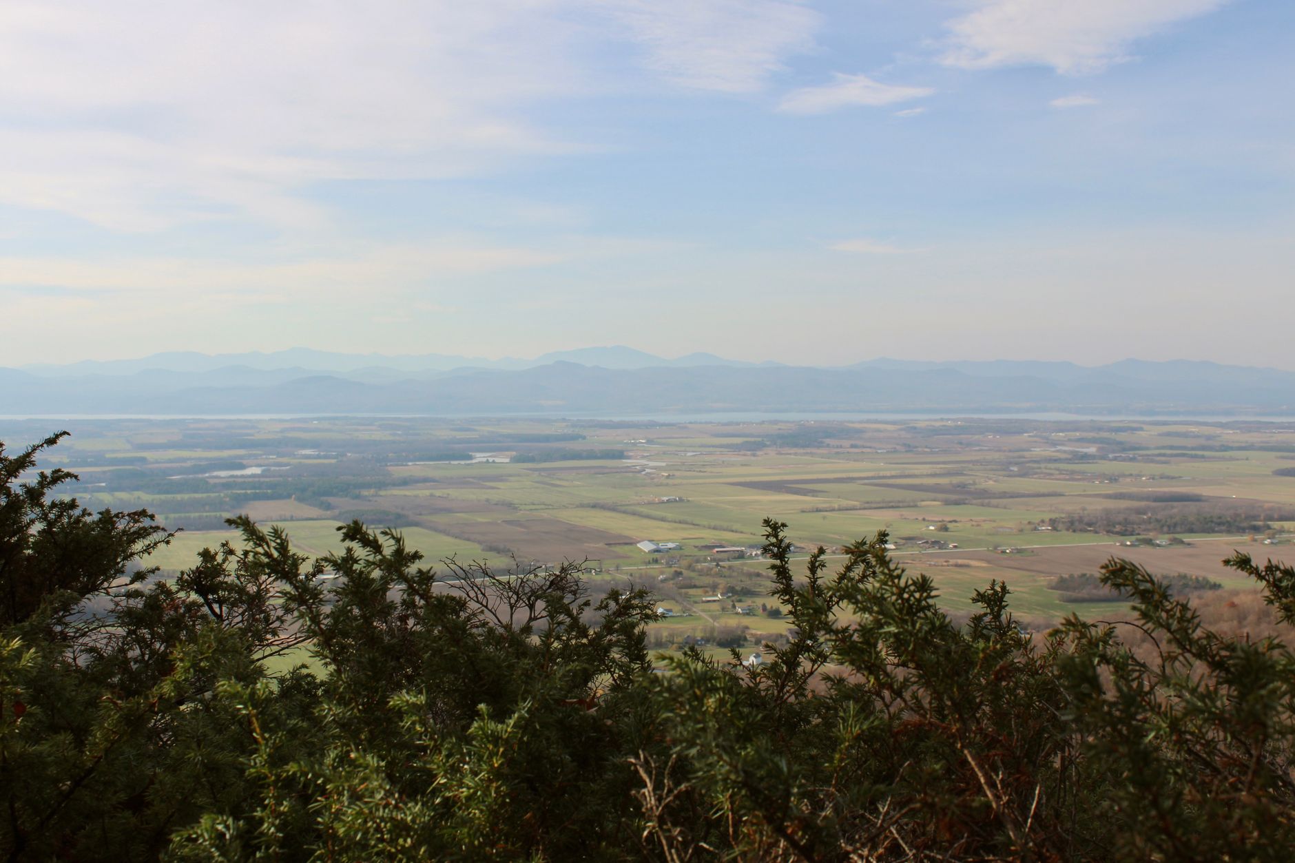
The summit of Camel’s Hump is a bare rock crown with a genuine 360-degree view, and on a clear day it is one of the great panoramas of the Northeast. West across the Champlain Valley the lake spreads out below with the Adirondack High Peaks — Marcy, Algonquin, Whiteface — rising behind it. North the Green Mountain ridge runs to Mount Mansfield and beyond toward Jay Peak and Quebec. East, past the Mad River and Winooski valleys, the White Mountains show on the horizon, with Mount Washington visible in good conditions. South the Long Trail ridge marches away over Burnt Rock, Ellen and Abraham toward Killington.
Treat the weather seriously. The summit is roughly 20 degrees Fahrenheit colder than the valley with wind that can be violent, and it can be sunny in Burlington and sleeting on top in any month of the year. Clouds close in fast; the exposed final scramble is slick and genuinely hazardous when wet or icy. Carry layers, a windproof shell, more water than you think you need, food, a headlamp and a paper map, and check the summit forecast rather than the valley one.
Two timing rules matter. First, do not attempt the mountain in mud season — the state and the Green Mountain Club ask hikers to stay off high-elevation trails from roughly mid-April to Memorial Day, when the thawing tread is destroyed by boots. Second, in winter the mountain is a serious undertaking requiring snowshoes or microspikes, real winter clothing and experience; the summit in February is an arctic environment, beautiful and unforgiving.
Mount Philo: Vermont’s first state park
Twenty-five minutes south of Burlington in Charlotte, Mount Philo rises abruptly out of flat farmland to 968 feet — a modest number that undersells it completely. Because the mountain stands alone at the eastern edge of the Champlain Valley, with nothing between it and the lake, the view from its west-facing cliffs takes in the entire valley: a quilt of dairy farms and hedgerows, the silver sheet of Lake Champlain, and the full wall of the Adirondacks beyond, with the Green Mountains at your back.
Mount Philo State Park, established in 1924, is the oldest state park in Vermont. A summit hotel operated here in the early 20th century, and the Civilian Conservation Corps built much of the current infrastructure in the 1930s — the stone walls, the picnic areas and the narrow, steep summit road that is still the way most people arrive. The park has a small campground with a handful of tent sites and lean-tos, picnic shelters, restrooms and a summit loop path along the clifftop with several distinct viewpoints.
You can drive to the top in a couple of minutes, and in season the road carries a modest per-vehicle fee. Walking up is better: the Mount Philo Trail climbs about 0.8 miles and 600 feet through hemlock and oak woods, steep in places but easily done by children, taking twenty-five to forty minutes. A network of shorter connector paths — the House Rock Trail, the Devil’s Chair spur — adds variety on the way down. The whole visit can be forty minutes or a lazy three hours with a picnic.
Hawks, sunsets and the best times to go
Mount Philo’s cliffs sit in a raptor superhighway. Because migrating hawks ride the thermals and updrafts along the valley edge, September and October bring thousands of broad-winged hawks, sharp-shinned hawks, kestrels, ospreys and the occasional eagle past the summit, sometimes in swirling kettles of hundreds at once. Volunteer counters are often on top with spotting scopes and are usually delighted to point out what is passing; mid-September on a day with a northwest wind after a cold front is the classic combination.
The other headline event is sunset. The overlook faces due west across the lake to the Adirondacks, which means Mount Philo is arguably the best easily reached sunset spot in Vermont. It is popular accordingly — arrive an hour early on a summer or foliage evening, and check the park’s closing time, which shifts through the season.
Foliage weekends in the first half of October bring the biggest crowds by far, and the summit lot is small enough that cars are turned away; go early, midweek, or walk up from the lower lot. Winter closes the road, but the park stays open for a quiet walk or snowshoe with the valley bare and blue below — one of the best cold-weather short hikes in the county.
Other summits within reach
If you have more days, the county and its edges hold plenty more.
Mount Mansfield (4,393 ft) — Vermont’s highest, 45 minutes east; hike Sunset Ridge from Underhill State Park for an alpine ridge walk, or take the toll road or gondola from Stowe.
Burnt Rock Mountain — a rocky, view-rich 3,168-foot summit south of Camel’s Hump on the Long Trail; a hard but rewarding half-day.
Bolton Valley & Bolton Notch — a resort with year-round trails, plus Preston Pond and the notch’s ledges nearby.
Snake Mountain — a gentle Addison County climb to a broad Champlain Valley overlook, less busy than Philo.
Hinesburg and Williston town forests — easy local trail networks, perfect for a rainy or short day.
Ethan Allen Homestead & Colchester Pond — flat riverside and lakeside walking minutes from Burlington.
What to bring and how to behave
The two mountains need very different preparation, and the alpine zone needs your cooperation.
For Camel’s Hump — proper hiking boots, layers plus a windproof shell, 2–3 liters of water, food, headlamp, paper map, and microspikes outside high summer.
For Mount Philo — ordinary shoes are fine; bring a picnic, binoculars in hawk season and a camera for sunset.
Stay on the rock — above treeline on Camel’s Hump, walk only on bare stone; the tundra plants take decades to recover from a footstep.
Respect mud season — stay off high trails from mid-April to late May while the tread thaws.
Start early — both trailheads fill by mid-morning on weekends; an early start also beats afternoon thunderstorms.
Dogs on leash — required in the alpine area and on Mount Philo’s summit loop.
Carry it out — there are no bins on either summit, and no facilities at all on Camel’s Hump.
Where to stay
Waterbury and the Mad River Valley put you closest to the Monroe Trail — village inns, farmhouse stays and Stowe’s larger hotel supply within half an hour, plus breweries and good food for after the hike. Richmond and Huntington sit at the western trailhead and offer quiet country lodging in the Winooski Valley.
For Mount Philo, Shelburne and Charlotte are minutes away, with inns and bed-and-breakfasts along Route 7 and the option of the Inn at Shelburne Farms nearby. The park’s own small campground is a lovely, simple choice if you book well ahead.
Most visitors base in Burlington or South Burlington, which puts both mountains within forty minutes and adds the widest choice of hotels in Vermont plus dinner and a lakeside evening after the walk. Use the search below to compare live prices, with free cancellation on most rooms.
Good to know
Common questions
How hard is Camel’s Hump?
Strenuous but non-technical: 5 to 7 miles round trip with 2,000–2,600 feet of climbing and a steep rock scramble at the top, taking four to six hours. The Burrows Trail from Huntington is the shortest at 2.4 miles each way; the Monroe Trail from Duxbury is the most popular at 3.4 miles each way.
Can you drive up Camel’s Hump?
No — and that is the point. There is no road, lift or building on the summit; it has been protected as wild land since Joseph Battell bought the peak in the 1880s specifically to prevent a hotel being built. Reaching the top requires hiking.
Why must you stay on the rocks at the summit?
Camel’s Hump holds about ten acres of true arctic-alpine tundra, one of only three such areas in Vermont, with relict plants left from the last glaciation. A single footstep can kill plants that took decades to grow and expose soil that then blows away, so hikers must walk only on bare rock.
Is there really a plane wreck on the mountain?
Yes — a B-24J Liberator bomber crashed near the summit in October 1944, killing nine of ten crew. Wreckage including an engine and landing gear remains on the slope near the top of the Monroe Trail, with a memorial plaque. Treat it as a memorial and leave everything in place.
What makes Mount Philo worth it?
It is Vermont’s oldest state park (1924) and the easiest great view in the state: a 968-foot summit reachable by a 0.8-mile walk or a short paved road, with west-facing cliffs over the whole Champlain Valley, Lake Champlain and the Adirondacks. It is the best sunset spot in the county and a superb hawk-migration lookout in September and October.
Every booking through Vermont Destinations funds one verified tonne of carbon removal — same room, same price, no markup.
Find a stay